Those of you who’ve been following my blog for a few years might remember the Black Moon Chronicles, a series of graphic novels by French author François Marcela-Froideval. That name might also sound familiar because he was one of Gary Gygax’s cohorts, who did a first draft of Oriental Adventures (which was never used), was the co-creator of the Greyhawk quasi-hero Kelanen, Prince of Swords, and it is said that he was to be “given” a section of the far western portion of Oerik to develop.
The legend/theory then goes that his later Black Moon Chronicles graphic novels were an expression of that intent, and thus they assumed the status of sorta-kinda-maybe-canon. The fact that the much-maligned Dragon Annual #1 map of Oerik has some names in that very region that are very similar to his own creations (specifically the Empire of Lynn, as opposed to his own Empire of Lhynn), adds credibility to the case.
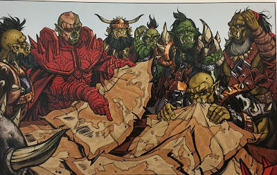
So, just today, over in the G+ Greyhawk community, W.K. “Icarus” Nolen discovered some new maps in the art of one of the newer volumes of the Black Moon Chronicles. Here’s the whole panel in question:
As he puts it:
The main one the half-orc in red armor is holding looks to me like it could be Oerik, essentially from a latitude of the Sea Barons on an angle across to Thalos in the Sundered Empire on the western shore. the big area of water in the middle would be the Sea of Hyperboria.
I think the map the orc with the map in his mouth is holding looks like the coastline of Western Oerik, if West were towards his face.
So, the two would line up with the eating orc’s right hand being at the same place as the red-armored orc’s left thumb.
Hmmm. Let’s see where this goes.
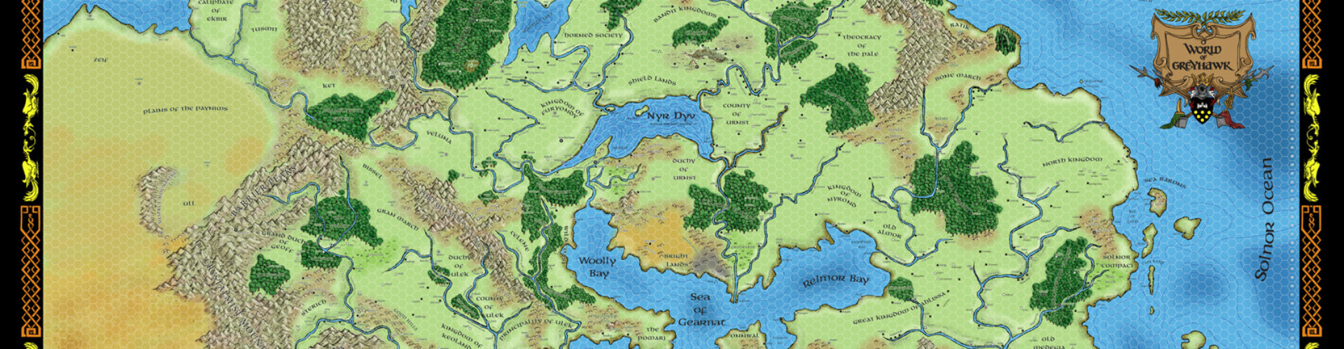
First of all, for reference, here’s the DA1 map:
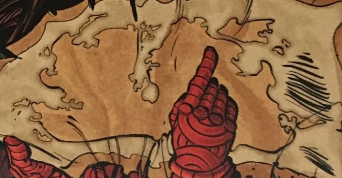
And here’s the first map Icarus mentions, rotated and cropped as he suggests:
Even if we are charitable and say the orc’s hand is covering up the entire Celestial Sea, I just don’t see it. There are peninsulas where none should be, and what Icarus calls the Sea of Hyperborea comes way, way too far south, and is too wide. Plus the whole of eastern Oerik is completely wrong. Even accounting for the vagaries of Medieval-style maps, I think it’s a stretch.
But what if we flip the map upside-down? We get this:
To my eye, this makes a LOT more sense. Bearing in mind that even if this is supposed to be an accurate representation, it’s going to be an accurate representation of François Marcela-Froideval’s western-Oerik-that-never-happened. So a close match to the DA1 map is not going to happen.
But here, we clearly see that big island at the southwestern tip of Oerik, next to the Barbarian Seameast. We see the islands of the Tharquish Empire, and we see the Celestial Sea (including the islands east of Erypt and the Gulf of Ra).
It’s not perfect by any stretch. The
island of Thalos (which we know from the Sundered Empire setting) is turned into a peninsula. Nippon is smaller and moved very close to the mainland and south at the same time. The Flanaess is atrophied to the point of near-non-existence. But if one were inclined to make a Medieval-style map increasingly inaccurate as one got further from its point of origin, that might make sense.
Let’s take a look at that second map, being chewed on by orc #2:
It’s hard to tell when you zoom in like this, but the center of the map is actually overlaid by yet another map, so it’s only the coastlines we’re looking at here. Here’s the relevant portion of the DA1 map zoomed in:
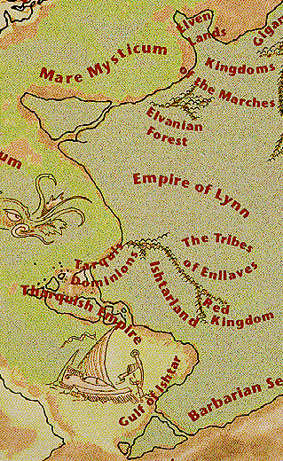
The Elven Lands (aka Empire of Ravilla in the Sundered Empire setting) get turned into islands, and Thalos is more peninsula than island, but we see the big triangular jutting-out of the Tarquis Dominions, and the coast seems to turn eastwards at the right point, even if the details are off. It’s possible.
So I come to a firm conclusion of “50-50, but even if it’s so, it’s not Greyhawk, it’s François Marcela-Froideval’s setting that never made it into Greyhawk.” Still, it’s a neat addition to the lore and something else to chew on. Now I have to buy more graphic novels!


I love this so much. It's crazy to think how long an easter egg like this was laying in plain sight.
Now how to explain that there are two European-style civilizations on opposite ends of the continent?
That's easy (and, I think, actually mentioned in-canon). The humans on the far western side of Oerik are descended from Oeridian explorers who sailed across the Solnor Ocean.