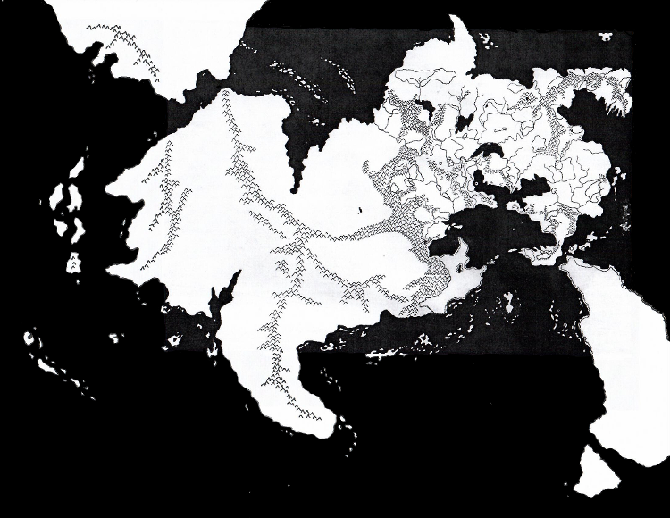
So, inspired by my article yesterday charting the history of canonical efforts to map and define the continent of Oerik, I thought it might be worth seeing what a non-canonical effort might look like.
And lo! and behold, my collection of back issues of Dragonne magazine, from the alternate universe where Greyhawk’s creator remained at the helm, did not disappoint. Behold an Oerik that might have been.

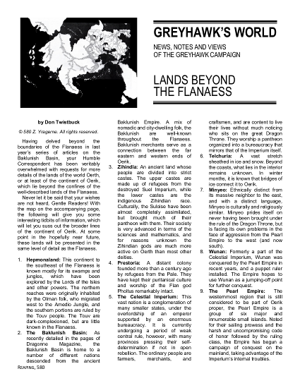
Honestly, TSR, this was all I ever wanted. No huge mega-continent desert just off the edge of the map; just a nice coastline, and some islands. Would that have been so hard? There’s a larger version of the map, and some accompanying notes, in this excerpt from Dragonne. Enjoy!
Does this mean that the Sundered Empire, and the Empire of Lynn/Lhynn, and so forth have no place on Oerth? Certainly not. As a matter of fact, the continent of Gonduria seems pretty under-developed and ill-defined at the moment…


Love it! Gonna use it!
The lost Dragonne articles are always my favorites.
I appreciate the more “intimate” western Oerik map, though admittedly I will go with the nation names from the Gord books (Changol, Jahind, and Mulwar “to the south” and Sa’han, Behow, and Chomur “to the west” of the Sea of Dust.)
Really good stuff, though, as always!
That’s what I did with my “Beyond the Flanaess” maps, and doubtless will do again when I re-do them to conform to this map. Zihindia is where Changol and Jahind and Mulwar are, and the Celestial Imperium is where you’ll find Sa’Han, Chomur, and Behow.
You can rarely go wrong with Gygax, of course, but there are some very-inspired fan creations for Beyond the Flanaess—in addition to Joe’s work, I’m very fond of Aaron “TalMeta” Sheffield’s Sunelan Coast materials on Canonfire! @ http://www.canonfire.com/cf/modules.php?name=Your_Account&op=userinfo&username=TalMeta and on his web site @ http://www.talmeta.net/maps/wog.htm
Allan.
I had not seen that when I looked at them a billion years ago! That’s terrific!
The writeups of Western Oerik are really cool. The thing I really find interesting is how so many of these lands seem inspired by Asian cultures. We have the Baklunish Basin, which is inspired by the real-life Turkish and Arab cultures, leading to cultures inspired by the likes of India, China and Japan. Meanwhile, to the south of the Flanaess we have a culture inspired by the Mesoamerican cultures.
I don’t know if it was Gary Gygax’s intent, but this builds a lot of parallels between Oerth and our real-life Earth. A lot of fans consider the Flanaess the equivalent of Europe, but I see it more as the equivalent of North America. The Flan, of course, are analogous to the real-life First Nations. While Gary Gygax said they weren’t based off that, that’s what they always suggested to me both in physical appearance and culture even in his own materials. Gygax also said that more than 20 years after the fact, when he also said that there were no good drow save for the insane, even though Vault Of The Drow contained Nilonim.
Quick correction: I’m pretty sure Pholtus is an Oeridian, not a Flannae, god.
Whoops! I was thinking of Tenh. Fixed.
Brilliant! This is exactly what Oerik should look like. When we are presented “Eastern Oerik” in the opening pages of the boxed set, we can clearly see “western Oerik” in the inset map. Not “central Oerik” or “east-central Oerik” or whatever. Oerik became this Pangaea mess.
What I like the most about cutting it in half is that it opens up the Baklunish cultural region more to the rest of the world. The Dramidj Ocean was too bound by the Black Ice, Icy Sea and Telchuria.
This was bugging me for months too. I kept reading all the information Gary had given about what Oerth was supposed to be. As per a previous e-mail to you, I ended up using a Google Earth Pro map with a 1:2 ratio to that I could flip and edit and stuff back into Google Earth Pro. For myself, I ended up with the world flipped east-west, with North America flipped back again, South America under water, and Asia replaced by an Asian-sized France.
Now my reasoning was “The Gnome Cashe” article from 1976 references four continents. The folio references four continents. The 1976 article says the world is backwards but doesn’t say how so it could be that Gary means east and west are flipped. Gary’s later company comes out with a version of Africa (called AEsheba) which I think could have east and west flipped and fit just fine. The only somewhat problem is Gary’s quote about placement of Francois’ continent. I found a posting he did that says, “Col_Pladoh wrote:
Well Michael…
Francois had a map of a continent and some islands to the east, and they were going to be added. The “Orient” wes actually to be past them, closer to the West Coast of Oerik.
Zeb took advantage of my being absolutely engrossed in the business affairs of TSR at the time–I was doing my best to keep the company from being forced into receivership, and i succeeded–but he managed to sink Francois’ material and use only his own during that time.
BTW, Len Lakofka had an eastern continental addition as well as the Lendore Isles, so what Iplanned to so was incorporate Francois’ and Len’s maps with Oerik, complete the lower continent below it, and have a real globe
So much for plans.
Cheers,
Gary”
So, do you readers thank that L1-L5 represents Len’s continental additions? Do you like Gary’s “Francois had a map of a continent and some islands to the east” being more east than Aquaria? Far enough east makes it Western Oerik like the Living Greyhawk and Chainmail maps. I don’t have any idea what the coastlines for Aquaria look like…but since the Aquaria maps we do have contain a west coast and both a Long Beach and a Shell city, I placed those over the top of my Long Beach, California and Shell Beach, California even though the coastlines don’t quite match up perfectly. Without a South America, my ithsmus that Frank says he has would have to be a hidden land bridge between Alaska and Oerik (because I’m thinking all of Aquaria is hidden somehow unless you sail there). But this Dragonne map is beautiful.
Nah, I think L1-5 were all on Lendore Island from the beginning. But if the Orient was going to be on a separate continent from Oerik, what was going to be in the western part of the continent, I wonder?
Oh, and I think fans have even more space to spread out if they think of Gary’s model as somewhat based on a hollow Earth model. That would allow for a Hollow Oerth and a hollow moon (maybe with continents that mirror the outside like the Burroughs model). Burroughs’ Barsoom already fits with what Gary was doing in the OD&D era (he sent some characters there as most of the people reading this already know). The http://www.erbzine.com/mag14/1497.html page shows that “Mars, Venus and even Mercury, the small rocky worlds, are hollow worlds” so there’s even more space to spread out.
Have you ever read my article “The Land of Black Ice and the Hollow Oerth”?
http://www.greyhawkgrognard.com/2010/07/06/land-of-black-ice-and-hollow-oer/
Holy crap. That was over ten years ago. I’ve been doing this a while!
I think I did read “The Land of Black Ice and the Hollow Oerth.” I’d be more inclined to use tunnels to access an Inner Oerth ala Journey to the Center of the Earth. But the Hollow World model is ripe for the picking too. I’m wondering where’s that information about a valley with it’s own sun…maybe that would make a good entrance… I see the Rift Canyon would make a good entrance. Your article “Let’s Read: Greyhawk Adventures (Part 10)” says, “Rigodruok – The Rainbow Vale, located in the Land of Black Ice. Sort of a riff on the idea of the Hollow Oerth, this is a warm and fertile bowl-shaped vale in the midst of the black ice, inhabited by humanoids, spiders, and cavemen, with plentiful diamonds.” The https://ghwiki.greyparticle.com/index.php/Rigodruok page ascribes information about this place to Dragon #230, but I don’t see it in that magazine. It sounds like someone started to design a Hollow Oerth and then right before publication changed the setting to a bowl at the North Pole.
Also, why Hyperboria is also called Telchuria? I consider this an ice pack over water. Same with Polaria. What continent names do you use? Where do you place them? Where there is a missing continent, do you consider it a sunk version of an Earth continent or an inverted height/depth?
Telchuria gets its name from Telchur, Oeridian god of winter. “Hyperborea” was the name in the DA1 article that accompanied the map, and is explicitly said not to be the correct name, just one the in-universe author was using. Like Nippon.