“Leda! Please don’t quarrel with our friend. You are allowing the archfiend his way when you do that,” Gord said gently. “His question was deserved. It was also practical.” The three had been chivvied and chased across the whole of the world. From the distant south, through the Moving islands, up and across Gonduria’s vast continent, and thence across the Agitoric Ocean to western Oerik’s shore. No fastness or barren or mountain chain had served to conceal them from the hounding of Tharizdun and his yeth.
— Gary Gygax, Dance of Demons, p. 402

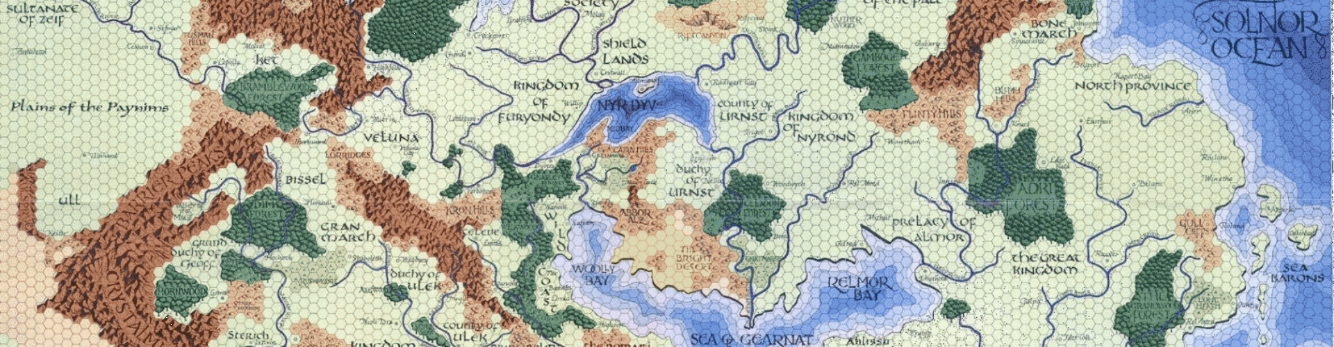
The location of the continent of Gonduria and the Agitoric Ocean has been a question that has vexed Oerthophiles for quite some time. We are told in the Guide to the World of Greyhawk Fantasy Setting that “Oerth has four great continents and countless islands, and four great oceans and countless seas which surround these bodies of land.” (Guide, p. 4) But the Guide only names one of them; Oerik, the continent on which the Flanaess can be found. The text accompanying the Dragon Annual #1 map clearly refers to Hyperborea
(the icebound land at the north pole of the planet) as a continent. So
that’s two down.
The names (if not the locations) of the oceans are all accounted for. The Solnor and Dramij Oceans appear in the original folio maps. The Ocean of Storms and the Oceanum Titanicum are in the DA#1 map. And finally the Agitoric Ocean is mentioned above, but there’s no indication of its location except that it is between Gonduria and the western shore of Oerik. Hey… wait a sec… that’s five oceans! Obviously two of those named above are actually different names for the same body of water. But which two? Back to that question below.
We are also told that Aquaria is one of the continents on Oerth, some 5,000 miles east of the Flanaess across the Solnor Ocean (which, we are told is only 3,000 miles wide!). Some sources state that Aquaria is on Aerth rather than Oerth, but there’s no reason there can’t be an Aquaria on both; the one on Aerth is 5,000 miles away, the one on Oerth is only 3,000 miles. Works for me. So that’s four continents named. But where the heck is “vast” Gonduria?
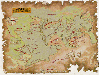
For a while, I was inclined to label the westernmost portion of the vast landmass found in the DA#1 map as Gonduria. In the same way that Asia and Europe are deemed to be separate continents even though they share an enormous land border, so too it made sense to me that Gonduria and Oerik could be situated. That would put “the western shore of Oerik” as the western coast of the peninsula upon which the Nippon Dominion is found and would fit in nicely with the quote from Dance of Demons, above.

Unfortunately, the publication of 2001’s Chainmail, with its “Sundered Empire” setting dashed this possibility. Although it is set in the northwest corner of that great landmass and thus adds some much-needed meat to an otherwise scant area of the campaign world, it is clearly stated in multiple sources that the Sundered Empire is situated in western Oerik. I don’t share the misgivings of many of my fellow Greyhawk fans
concerning the setting; I think it has a lot of possibilities, and can
be made to fit with the rest of what we know about the area.
We also know that François Marcela-Froideval’s campaign, which includes the lands of Lynn (Lhynn), Erypt, etc. fills up the southwestern portion of Oerik. His Chroniques de la Lune Noire have a ton of information on this region, but that’s a subject for another post…
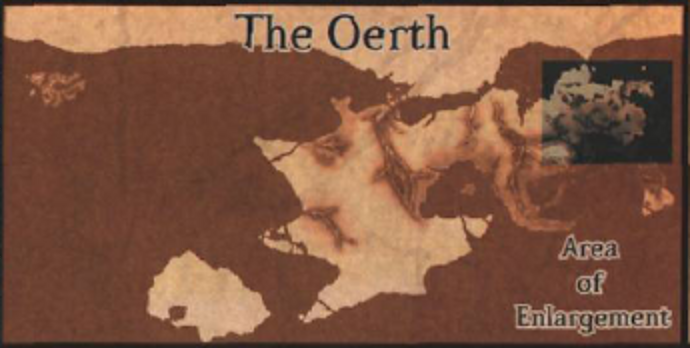
There’s also the inset map from the Living Greyhawk Gazetteer that shoves Fireland some 3,500 miles to the west and shifts the landmass seen in the lower-right corner of the DA#1 map over to connect with the landmass in the lower left corner, creating one continent-sized landmass southwest of the Tharquish Empire. Given the fact that the DA#1 map is presented as a sort of “adventurer’s map” and is not necessarily 100% accurate, these sorts of changes pose no problem. (The map I found to the right is from the Dungeons and Dragons Gazeteer, and thus isn’t exactly the same as the inset map from the LGG, but it’s close enough to give you an idea of what it looks like. The one in the LGG has some more empty space off to the right and slightly different labels.)
That landmass, I think, fills the bill for Gonduria. It’s in the right place (assuming the waterway between it and Oerik is in fact the Agitoric Ocean; we’re still working on that superfluous fifth ocean). Is it “vast”? Well, it’s about the same size as the Flanaess, so given the fact that “vast” isn’t the most precise unit of measurement ever invented, I’d say it could apply. It’s certainly in what would be called “the distant south” from a Flanaess-centric point of view. And, given its position, that would cinch the identification of the Agitoric Ocean as being one in the same as the Oceanum Titanicum. From our postulated Gonduria you cross it to get to the western shore of Oerik. Nice and neat, methinks.

We still need to place Aquaria, home of the Aqua-Oerdians and Frank Mentzer’s campaign since 1976 or so. Time for an itsty bitsy bit of math. (I know, I know, I’m ignoring the implications of a spherical world and Mercator projections and that stuff. I’m a history major, not a geography major.)
Oerth has a circumference of 25,200 miles. Oerik is (very) roughly 10,000 miles across, including the Flanaess. The inset map from the Living Greyhawk Gazeteer is about 21,500 miles across from edge to edge. Coincidentally, from the eastern edge of the Flanaess on the LGG inset map is… 3,000 miles. Just the right amount of distance to cover the known width of the Solnor ocean before it hits the edge of the map. And that map also leaves us with roughly 3,700 miles to have another continent which would be… Aquaria. Not that Aquaria has to be 3,700 miles across; it could be significantly smaller. But it would be continent-sized, and therefore would serve to separate the Solnor Ocean from the Oceanum Titanicum/Agitoric Ocean.
So there it is. Gonduria is the continent southwest of Oerik. The Agitoric Ocean is the same as the Oceanum Titanicum, and is separated from the Solnor Ocean by Aquaria. Four continents, four oceans, lots of disparate canon sources, some of which are mutually exclusive, reconciled. Ta-da! If you put the pieces together, it looks something like this:
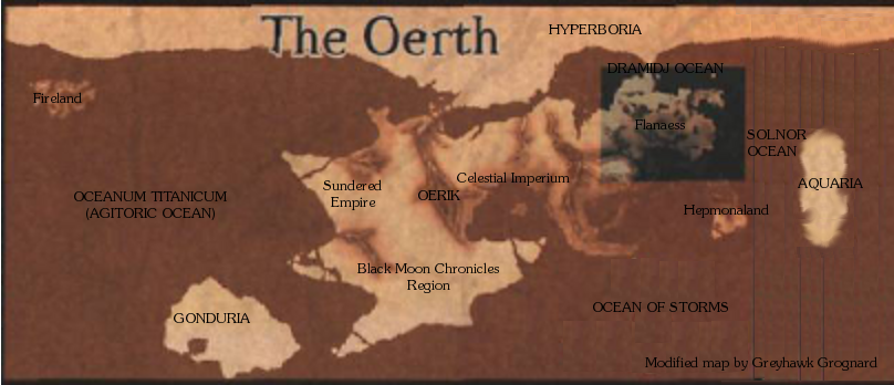
(Note that Aquaria is on there just to establish its position, not to indicate its actual shape. Continents and oceans are capitalized.)
I realize some of the above conclusions diverge from those of other Oerthophiles, some of whom name Hepmonaland as a continent, and who conflate the Agitoric Ocean with the Ocean of Storms, along with other differences. But given the sources, I think my solutions make a lot of sense, and of course since it’s all “canon reconciliation” there is no single right answer. If I’ve overlooked anything, I’m sure my gentle readers will let me know.
____________________
Also, please take a minute to check out the Adventures Dark and Deep Kickstarter campaign. Help make the ADD rules supplement, suitable for use with all 1E-compatible games, a reality!


I hope a sketch map illustrating your conclusions is forthcoming 🙂
Ask and ye shall receive, AMBotAW. I've updated the post with a quick map that puts all the pieces together.
Damn Joe that's mighty deep geographical investigating! Your results I think are the best compromise for all sources I've seen yet.
The "terra incognita" placement of Aquaria's location amuses me too, for it reminds me of my South Seas map of the Flanaess where I hazed out the Spindrift Isles due to efforts by the elves to isolate their existence there. In a similar fashion Aquaria could be placed definitively for hardcore map fiends who want a perfect map, but in a practical sense, having a mystery coninent out there adds to the allure for a high seas campaign.
I'm still no fan of a Oerik pangea or even as a super continent, but your map looks good and your reasoning is sound. Nice work! I expect you'll map the entire planet in hexographer soon, no? 😉
I'll add, also, that as a point of order, teh Dramidj Ocean is not really very large on the DA1 map and is comparable to the Celestial Sea in size. I wonder how it ever qualified to be an "ocean"?
I can't put my finger on it right now, but I do recall reading that the Dramidj Ocean circumnavigates the planet encompassing all the waters south of Hyperboria. Much like the Arctic Ocean on Earth.
I'm not a geographer or a vexed Oerthophile. I read the Gord quote differently than you've reasoned, but as you're fitting so many other sources together I can't disagree.
Some fine sleuthing there, including Aquaria and Lhynn as well. I hadn't thought of those regions even though Gygax had intended including them in his own published Oerth. Oerth could have grown as a neatly shared campaign.
Last night, I posted a bunch of Gygax's world maps on my blog. You've got me thinking about the larger sandbox, "canon reconciliation" included. Thank you.
Joseph: The source may be The Adventure Begins
"The fourth and last of Oerth's great oceans, usually called the Dramidj Ocean, abuts part of the northern continent of High Boros, merging with the Solnor and almost encircling the arctic wastes. Some cartographers believe the Icy Sea is part of this great circumpolar ocean and not part of the Solnor."
That's the quote, Yggs. Thanks.
Well, there we have it 🙂 Nice work!
Uhh… one question. What about Polaria? Where does it fit on your map? Is it just an island, something more, or did you just miss it? Other than that and the Dramidj ocean being too small (which would be fixed with the merging of that and the icy sea) you did good work! Btw, just a suggestion as it increases itss functionality. Aquaria, while a continent in its own right, is a small one, if you merged the north coast of it with the south coast of Hepmonaland. You would increase the size of the continent and still keep its functionality (basically Hepmonaland would become a large pininsula), just a suggestion though as it works now. Good work though, really good! Kudos on your next project!
According to DA #1, Polaria is "Not a landmass at all, but a collection of islands locked in a semi-permanent ice cap".
So on that basis, I don't count it as a continent.
Thanks for the kind words, though– glad you enjoyed the post!
K, just being sure. And again, kudos on the work, it had to take a long time to line up right. What did you think about the rest of the post?
K, just being sure. And again, kudos on the work, it had to take a long time to line up right. What did you think about the rest of the post?
Here's a link to one person's take on Aquaria in his version of Oerth called Terra. On his map, he has it listed as Antaria.
https://kain-darkwinds-savage-tide.obsidianportal.com/wikis/terra
It uses the shape of Gonduria and placement as you may see is far to the south though it also contains more continents than Oerth is supposed to have.
I came across a map from a product called Æsheba: Greek Africa that it appears Gary Gygax, Frank Mentzer and others produced for an African setting in the period just after the 'Night of the Long Knives'. The first thing that is interesting about it is the distinctive coastline similarities between the northern half of the map and the limited southern coastlines we see for Gonduria in Dragon Annual 1. The second thing that is interesting about this version of an African setting is that the continent does not include an Egyptian civilization consistent with Erypt being located on Oerik. Finally, it apparently has a Greek colonial theme, consistent with the known declining Greco-Roman Empire of Tharque nearby on the Western Oerik coastline. Seems to me the continent of Gonduria may have been published upside down under a pseudonym by EGG. Here are two links to images of the map: https://images.bonanzastatic.com/afu/images/ed5e/7d6d/37d8_4717119871/s-l1600.jpg and https://images.bonanzastatic.com/afu/images/bf61/bb6f/e740_4717119919/s-l1600.jpg