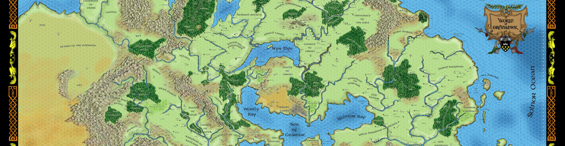
Purely as a matter of personal preference, though, I don’t much care for the style of map that is currently the rage amongst my fellow Flanaessophiles (seen in the aforementioned issue of the OJ). The original maps of the Flanaess, created by Darlene, were and remain the benchmark against which all other such fantasy cartography is measured.
Fortunately, Joe over at Inkwell Ideas has something to help. His Hexographer program (which I heartily recommend) is capable of making maps that, while not exact, perfect copies of the Darlene style, certainly come close. I found it worthwhile to have the professional version, which allows the import of custom map symbols (such as the volcanoes in the map below, in the southern portion of the Hellfurnaces).
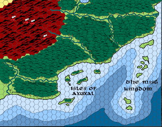
So, just as a test, I decided to take a move in the direction of fabled Zindia, the Pearl Sea, and Nippon, and put together a map of the southern half of the Amedio Jungle (which was detailed in the 3.x module The Scarlet Brotherhood). When printed, my map should fit along the southern edge of the Darlene map. This is just a test, mind you, and I don’t claim perfection by any stretch. But I’m reasonably pleased with the result.

The idea now is to move westward along the coast, slowly working my way to Zindia (which itself contains such fabled lands as Jahind and Mulwar) and then expanding out beyond. The above map took several hours, but a lot of that was due to the fact that I was experimenting, choosing fonts, creating some custom icons, and the like. It should go much more quickly the next time.


Whoa! That map is quite awesome. I'm wondering now why I don't have hexographer? Your sorta right about the realistic map craze, which I liken to art really. Those bring to my mind the gorgeous Middle Earth maps put out by ICE. However as a GH fan yes, Darlene's utilitarian map done in a calligraphic hand is the perfect balance between form and function.
That map you made really has that Darlene vibe. I think its the coastline color and fonts that sell it for me.
Your subject of southern Amedio is timely too as my campaign is gravitating that direction currently. So…yoink!
It's interesting to hear your views on mapping styles. After using CC3 for years, I recently moved on to Fractal Terrains and was amazed at the realistic look of the maps it created. After the initial amazement, I started to feel that something was missing. It took a while, but eventually I came to the conclusion that maybe I didn't want such realistic maps as much as I thought I did. Upon reflection, I came to the conclusion that Darlene's GH map is my all-time favorite map and perhaps that style is what I should be working on.
I love what you've done. Looking forward to seeing more!
Nice! Yes, Hexographer is indeed a boon to us all…
Very nice maps, Joe! I grabbed a copy of Hexographer during their GM's Day sale last weekend just because I really like how it allows you to emulate the Darlene GH map style.
Agreed on all counts. Love the Darlene Pekul style. I'm curious how well it holds up on a smaller scale map, with roads, streams, ruins, villages, etc.
Minor thing, Scarlet Brotherhood was a 2.0 product, and quite a decent one at that.
Everything you do seems intent on making me want to ditch CC3. You fiend. This is a superb map! 🙂