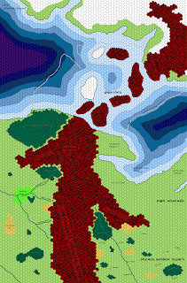
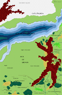
As usual, click to embiggen, and the link to the best-res version is over to the right, in the “Free Resources” section.
I anticipate a new version of this map will be forthcoming with changes to the lands west of the Stormwall Mountains once I get to work on the map immediately west of it, because that’s just how these things go. But this’ll do for now.
Note in particular the winter ice bridge that connects the mainland of western Oerik to Telchuria (aka Hyperboria). Naresh controls everything from the Arfast Forest to the towns beyond the Flailwood, but it’s mostly scattered pockets of gnolls and other fell beasties, scattered over a wide area. Their southeasternmost lands used to be under the control of Suhfangese expatriots who had set themselves up as local warlords, but who grew too reliant on their gnoll mercenaries and were overthrown one after another, until now the gnolls are coming up against Suhfang itself. Naresh also disputes the claim of the High Khanate to the Last Plains and the Spearguard Peninsula, and clashes between the two are common, but for now the attentions of Jangir, Priest-King of Naresh, are turned westward…
EDIT: By the way, there’s just one new map, covering both Naresh and northwestern Suhfang. The map I posted next to it is the Central Suhfang one. A couple people seemed to be confused by the naming.


Nice work, Joe: I'm definitely enjoying this series of maps and lands!
Allan.
On one hand, it looks fantastic. On the other hand (and this has been my complaint about the expanded map since it appeared in Dragon), it looks bloody empty compared to the Flanaess. Empty and monotonous. :/
I, uh, can't seem to find the link to download the Northwestern Suhfang one. All I can get is Naresh.
Lovely addition. I've used Hyperboria before but never got down to Gigantea. I hadn't thought it was an icebridge, nice!
p.s. To faoladh: Naresh and NW Suhfang is the same region.
Ah. Heh. Whoops. So it is. For some reason, I was thinking that the map of Central Suhfang was the one I was missing, but I already have downloaded that I see.
Nellisir: I agree on principle. However, there are some regions (what I call the Sea of Grass, for example), that are supposed to be vast, grand, empty spaces.
The regions to the west of the mountains are sparser now than they ultimately will be, in the same way that I was able to add a lot of detail to break up the Celestial Imperium. Likewise, not all deserts are trackless wastes, and they'll have some features, tribal inhabitants, etc. to fill them up as well.
What the Sundered Empire setting calls the Disputed Lands don't by any stretch of the imagination have to be devoid of population…
More great maps, Joe!
I agree about the 'vest, open spaces'. While the Flanaess is full of small fuedal kingdoms, I've always pictured the western portion of the continent to be open & emptier, partly because of the Twin Cataclysms, but mostly because of the wide open geography.
Are the High and Low Khanates (i.e. the Sea of Grass) the original Oeridian homeland? Presumably where they domesticated the horse?