
I’ve been going through various campaign worlds, and especially the cartography thereof, and noticed something rather striking. Strictly in terms of cartography, most of the most successful fantasy gaming worlds have what I would call “interesting” cartography. Specifically, large inland bodies of water that allow for aesthetically pleasing and varied contours in what would otherwise be large dull areas of solid terrain. For instance:
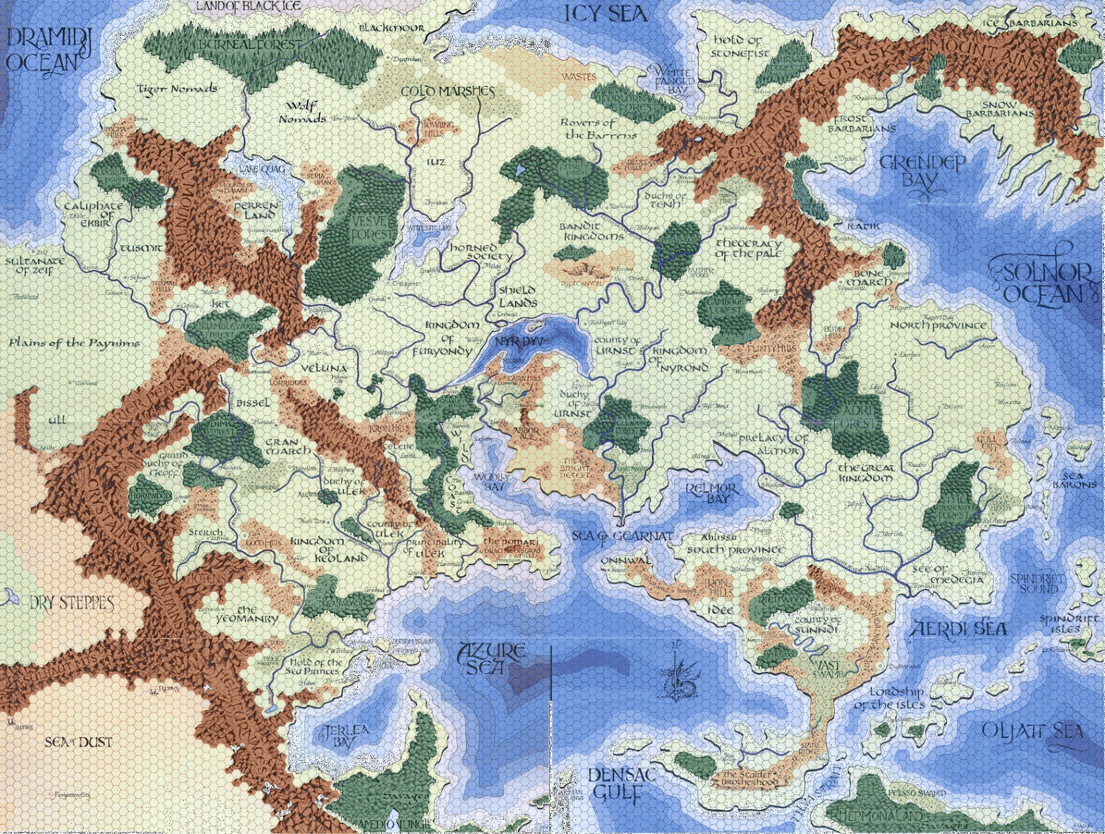
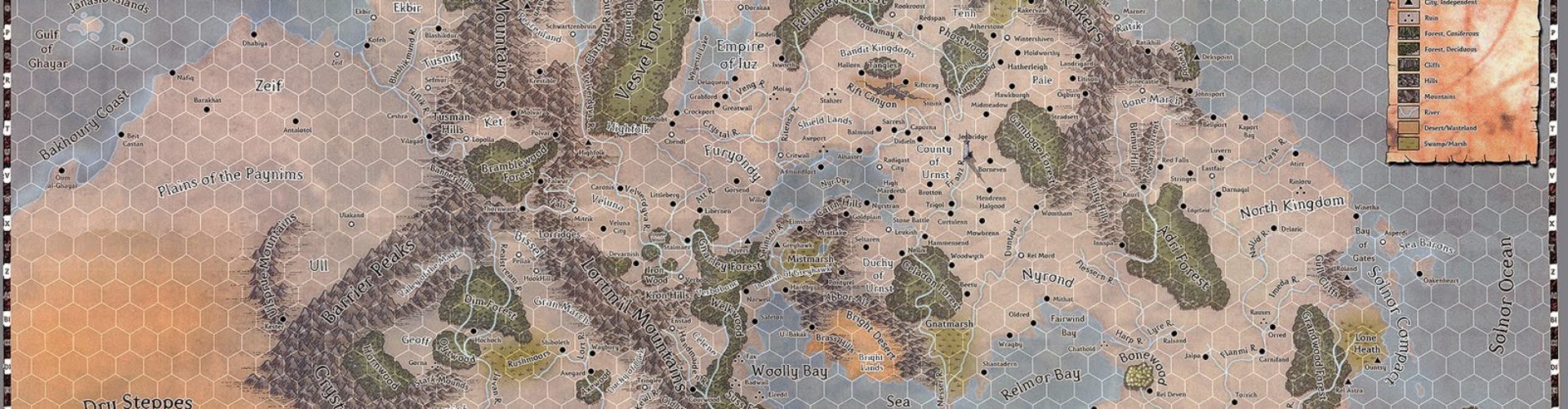
The Flanaess has the Azure Sea, the Sea of Gearnat, the Woolly Bay, and of course the Nyr Dyv. All bodies of water that extend well inland, breaking up the large stretches of land with large bodies of water with “interesting” contours. Lots of bays, inlets, etc.

Faerun has the Sea of Fallen Stars, the Shining Sea, and the Lake of Steam, all of which perform a similar function. They break up large land masses and provide lots of visual texture for the lands around them.


And of course…

Given the history of the Mediterranean in the history of the world, one wonders if we would have seen any of the cultures of the Greeks, Egyptians, Romans, etc. evolve if they had not had access to its waters (which, in everything up to modern times, was a quicker and cheaper way to travel long distances than overland, with certain exceptions). And if you look at it from a cartographic point of view, it certainly divides Europe from Africa with intriguing contours.
Contrast these examples, then, with something like this:

Masterful storyteller and linguist though he may have been, no one claims Tolkien was an inspired cartographer. Middle Earth is, plainly, dull in terms of its geography. If the Brown Lands had been a sea or large inland freshwater lake, connected perhaps to the Sea of Rhun to the east, I think the map would have a lot more verve.
Speaking purely on an aesthetic level, what do you think contributes to a fantasy world map being interesting?


This is a question I have nevr been able to answer, because there are areas of the world, like India, China, and Persia that have had rich myths and history but look boring on maps. And I know that my maps are my greatest failing as a DM because I cannot draw a place that looks interesting to explore.
I'd add two more real world areas to the list; the Caribbean and the eastern coast of Asia from Malaysia/Indonesia to the Kamtchatka Penninsula.
Dark Sun with it's Sea of Silt may qualify as well.
Interestingly, despite the inland Vilayet Sea, I don't think the Conan Hyborian Age really qualifies, mostly due to the uninteresting coastline for the rest of the map.
This. :p
I was wondering how large the areas in the other maps are, because I think that Middle-Earth's map would have been better, if the scale was larger/smaller.
I haven't tought about this before, but I like variety in terrain, and I don't mind large bodies of water, but rivers, mountains, etc. work for me too.
See my profile if you want to see what kind of maps I think are nice, or at least fun to make. 🙂
Keep in mind that that's half of Middle Earth. The Eastern end was sunk.
What makes a fantasy map interesting? Well, it's definitely not the naming of the features. It seems like it's a matter of many varied types of terrain with sufficiently large bodies of water to enable seaborne adventures and mountains and ice that act as natural barriers to dangerous areas.
For me the landscape of Tolkien's maps has the same effect. The mountains and forests break up the image the same way the bodies of water do in the maps you describe.
But that's not what makes a map compelling to me. I like to get up close and look at the minutiae. I love Tolkien's maps because I love to look up close and see Mirkwood, Angband, and Minas Tirith. I like the map of Beleriand because I can find the Girdle of Melian and Nargothrond listed on it. I love the Ultima game maps because I can read the runes, find the moongates and the shrines, and track the roads between the towns.
For me, that's what makes a compelling map. Give me a map I can happily get my nose up against, so I can find all the castles and haunted mountains listed on it.
The answer to India, China, Persia being geographically (or aquatically) boring is the presence and importance of major rivers.
If we are talking about the use of maps in adventure campaigns, rather than just looking at them and proclaiming them interesting, then it's a must to offer a choice between harder and easier areas, harder and easier routes – which means both that all areas should not be connected with all other areas, and that most areas should have multiple connections. A balance between a meaningless flurry of wonders, and a dull vista, must also be struck. There should be areas of the predictable that set off areas of the wondrous like the velvet that encases a jewel.
Always into maps and I would say that it's the maps that get me into a campaign or not.
My own campaigns always start with a map and the story grows from there.
And , of course, you still have the possibility of the cartographers of old. When you had a large piece of land that looked boring and featureless, you still could draw a big monster…
Another thing on fantasy rpg maps. A couple of imposing desolate spaces with something mysterious and alluring within it. Also those provocatively named blank spaces that just beg for adventurers to fill in some details.
JB, given your epic work on the expanded world of Greyhawk map, why are you bothering to ask other people what makes for a good campaign map?
Well, jdh, even though I have a fairly good idea of what *I* like in a map, it's always good to hear from other folks. It's a matter of taste, and I always like to hear reasonable opinions from folks who have a different take on things. After all, if it was all supposed to be about me, I wouldn't have comments on at all. 🙂
Agree completely with jdh's compliments on your excellent expanded Greyhawk map work – still hoping you decide to tackle Hepmonaland one day!
These are interesting comments.
I think the west of Middle-Earth sunk and the east stayed the same. I don't like how Tolkien's mountain ranges are so straight. Maybe they'd look less straight on a globe.
I think the JG map looks terrible when you zoom out and see the whole world since it's one big rectangle of land masses.
I upgraded Google Earth and now it doesn't work with my old video card. Anyone want to see if it'll view Mars and let you see elevations? I think it would make a great map if it was flooded to some level.
I think there is a well known author that used a flooded map of Maine to make an organic looking map but I can't think of how that was right now.
0 elevation for Mars maps:
According to:
http://en.wikipedia.org/wiki/Geography_of_Mars#Zero_elevation
The datum for Mars is arbitrarily defined in terms of a constant atmospheric pressure. During the Mariner 9 mission, this was chosen as 610.5 Pa (6.105 mbar), on the basis that below this pressure liquid water can never be stable (i.e., the triple point of water is at this pressure). This value is only 0.6% of the pressure at sea level on Earth, which forms the zero elevation datum for our planet. Note that the choice of this value does not mean that liquid water does exist below this elevation, just that it could were the temperature to exceed 273.16 K.[2] (0 degrees F)
http://flyingdildos.com/VenusElevationsMapbyNASA.png
http://ces.iisc.ernet.in/hpg/envis/Remote/section198_files/Fig19_34.jpeg