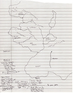
In my first installment in my NaCaCrMo series, I have a quick sketch of a map done, a big concept for the campaign, and a few details that occurred to me as I was contemplating the whole thing. Here is the map I came up with, along with marginalia which I’ll transcribe below (click to embiggen):

One of the core ideas of starting off an adventuring party is to have them come from somewhere else to the place where the adventure is, to give a reasonable explanation for why they wouldn’t intimately know the terrain, NPCs, local secrets, and so forth. In the original DMG, Gary Gygax gave some excellent advice on the subject:
As background you inform them (the players) that they are from some nearby place where they were apprentices learning their respective professions, that they met by chance in an inn or tavern and resolved to journey together to seek their fortunes in the dangerous environment, and that, beyond the knowledge common to the area (speech, alignments, races, and the like), they know nothing of the world. Placing these new participants in a small settlement means that you need do only minimal work describing the place and its inhabitants. — AD&D Dungeon Masters Guide, p. 87
So here’s where my first concept for the setting comes from. The whole thing is a recently-colonized island, or subcontinent, or continent. The kingdoms doing the colonizing have only been at it for a century or so, there’s a multiple-month lag in getting there from the homeland, and the settlements are still very early in the process of becoming secure. There are only a handful of actual towns, settlers are coming over and clearing land, a few intrepid explorers have mapped out some of what’s out there, but there’s a huge frontier, mostly unexplored, filled with mountains, forests, monsters, and mystery.
That gives a perfect excuse for the PCs to be fresh off the boat (literally!), almost completely unfamiliar with their new home, and with a built-in excuse to go off exploring. Perhaps there’s even a bounty on bringing back new and better maps, locations of valuable resources, and so forth.
In order to do this, I looked to the European settlement of North America. The map above doesn’t have a scale, intentionally. When I did some back-of-the-envelope calculations based on the colonies from New England down to Virginia, a population of 100,000 after a hundred years of settlement activity wasn’t excessive, and a scale of about 400 miles long and 200 miles wide would be about right, if I’m aiming for a 1720’s scope.
Note that this does not mean I’m going for a 1720’s level of technology. I’m just looking for historical patterns of colonization, exploration, and population growth. Fast forward 100 years from Plymouth Colony, and we get about that number of people and area of development. Still all very rough and dangerous and unexplored, though. Just what I’m going for.
There are three competing powers who have established colonies here; the colonies are Aedgaria (split into north and south), Lippegen, and New Valais. I envision them as (very roughly) English, German, and French. Aedgaria is the latecomer with the worst pickings, as both Lippegen and New Valais have solid routs to the interior, while North Aedgaria is stuck with a more northern route, with worse climate. Stretching the American colonies idea, North Aedgaria is New England, Lippegen is New York/Pennsylvania, South Aedgaria is the mid-Atlantic states, and New Valais is Virginia. Again, these parallels are more for scale than anything thematic, except for South Aedgaria being cut off from the interior.
It’s also worth noting that setting up the campaign this way makes it much easier to head towards the AD&D “endgame” of clearing land, building a castle, and ruling over peasants.
Transcribing my margin notes on the map above (just stuff that occurred to me as I was contemplating the map):
Humanoids
Goblinoids – mercenaries brought over by Lippegen and New Valais. Many deserted, now indigenous/feral.
Orcs – Natives. Unknown in Hanar-across-the-Sea
Demihumans
Native Wild Elves.
Other elves/dwarves/etc. brought w/Hanarians [I seem to have settled on “Hanar” as the name of the continent whence all the settlers are coming]
Most elves – Valais
Most dwarves – Lippegen
Most halflings – Aedgaria
Native druegar
LOST ARTANIS
Former big empire, suddenly destroyed. Why?? Ruins.
Secret – There were two civilizations, one much earlier. Not obvious. High Tech (steam-magic)
Religion
Valais – Druids
Aedgaria – Clerics
Lippegen – ???
Pop approx 130k
That took about an hour. Can’t wait to see where this leads me!


Can you point us to the website for NaNoCMo?
I'm doing the writing one this year but I would love to keep track of it for next year.
lol… you're looking at it. It's just something I made up to hang a hook on this series of posts. 🙂
How fun! Good show!
Cool idea! I'm participating in NaCaCrMo over at http://www.deepsheep.com !
Someone else taking up the challenge. Whodathunkit?
http://www.sycarion.com/november-campaign-design/
And another…
http://thedicemustroll.blogspot.ca/2017/11/nacacrmo-i-eastmount-general-overview.html
Really interesting concept. I think you could even apply this to the Flanaess-I've always felt that the real-world analogue to the Flanaess is not Europe, but North America.
We have the Flan, who are much like the real-world First Nations (bronze skin, black hair, mistakenly assumed to be primitive when they had their own sophisticated civilizations, etc.) along with the lighter-skinned settlers in the Oeridians and Suel who came later and who brought their feudal cultures along with them. It also makes for an interesting twist on the "endgame", as you put it-along with inherently evil creatures like orcs and goblins, you also have competing human communities as well.
Yes, the Flanaess is based on North America. It's the Wild West!
Even the map is of Chicago turned upside down or something, it's really interesting to see what Gary cribbed for it.